


SKU/Artículo: AMZ-1597750603
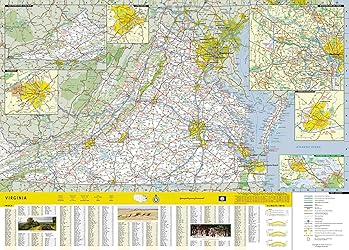
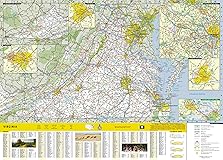
Virginia Map (National Geographic Guide Map)
Format:
Map
Detalles del producto
Disponibilidad:
En stock
En stock
Peso con empaque:
0.30 kg
0.30 kg
Devolución:
Sí
Sí
Condición
Nuevo
Nuevo
Producto de:
Amazon
Amazon
Viaja desde
USA
USA
Sobre este producto
- • Waterproof • Tear-Resistant • Travel MapNational Geographic's Virginia Guide Map is an unparalleled and expertly researched guide to the "Old Dominion." The main map shows the road network, with clear designations for free access and toll highway; interstate, state and country routes; other paved and unpaved roads; and scenic drives with their waysides stops. Major highways are shown with mileage markers. Pinpointed are hundreds of points of interest, national and state recreation areas, visitor centers, ski areas, hospital and airports. An index of counties, cities and towns will assist in finding your destination quickly. Inset maps cover some of the largest cities and metropolitan areas, including the Washington DC area, Richmond, Charlottesville, Roanoke, Lynchburg, Colonial National Historical Park and Hampton Roads. Visitor information and inset maps are shown for Shenandoah National Park and the Blue Ridge Parkway scenic drive. Other popular points of interest, a chart of national park services and a calendar of events are also provided along with contact details for all listings.Every State Guide Map is printed on durable synthetic paper, making them waterproof, tear-resistant and tough — capable of withstanding the rigors of any kind of travel.Map Scale = 1:1,140,000Sheet Size = 24.75" x 17.75"Folded Size = 4" x 8.75"
S/ 60.86
44% OFF
S/ 33.81
IMPORT EASILY
By purchasing this product you can deduct VAT with your RUT number
S/ 60.86
44% OFF
S/ 33.81
con envío
Compra protegida
Disfruta de una experiencia de compra segura y confiable
![]() Garantía de entrega
Garantía de entrega
Con Tiendamia todas tus compras cuentan con Garantía de Entrega o devolución total de tu dinero.
Compras 100% seguras y garantizadas, para que pidas lo que sueñas y lo recibas del mundo a tu puerta.
Saber más.Visa
Mastercard
American Express

