


Garmin dēzl™ OTR710, Large, Easy-to-Read 7” GPS Truck Navigator, Custom Truck Routing, High-Resolution Birdseye Satellite Imagery, Directory of Truck & Trailer Services
Disponibilidad
En stock
En stock
Peso con empaque
0.32 kg
0.32 kg
Devolución
No
No
Condición
Nuevo
Nuevo
Producto de
Amazon
Amazon
Sobre este producto
- 7” touchscreen truck navigator offers a bright, crisp high-resolution display .Control Method:Touch.Special Feature:Touchscreen,Bluetooth.
- Get custom truck routing (Not available in all areas. Vehicle characteristics may not be accounted for in all route suggestions. Defer to posted signs and road conditions.) based on the size and weight of your truck, and see alerts for upcoming bridge heights, weight limits, sharp curves, steep grades and more
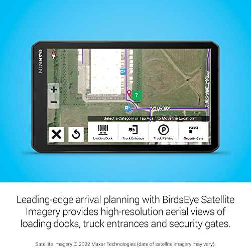
- Leading-edge arrival planning with BirdsEye Satellite Imagery provides high-resolution aerial views of loading docks, truck entrances and security gates
- The route planner feature helps drivers review their complete routes and determine the best places for fuel stops, comfort breaks and overnight stays
- Truck & Trailer Services directory allows drivers to filter truck stops by brand or amenity, such as “Love’s” or “Showers”
- PrePass notifications help drivers save time and improve efficiency with on-screen weigh station and bypass notifications; requires active PrePass account and use of the dēzl app on your compatible smartphone with BLUETOOTH wireless technology
- Integrated map updates of North America with coverage of the U.S., Mexico, Canada, U.S. Virgin Islands, Cayman Islands and Bahamas
$945,59
44% OFF
$525,33
Producto no disponible
Este producto no está permitido por la aduana del país en categoria 4x4
Este producto viaja
de USA ![]() a tus manos en
a tus manos en
![]()
Compra protegida
Disfruta de una experiencia de compra segura y confiable
![]() Garantía de entrega
Garantía de entrega
Con Tiendamia todas tus compras cuentan con Garantía de Entrega o devolución total de tu dinero.
Compras 100% seguras y garantizadas, para que pidas lo que sueñas y lo recibas del mundo a tu puerta.
Tarjetas de Débito y Crédito
Visa
Mastercard
American Express
Dinners
Discover
Alias
Pagos a través de PayPal
Compra procesada en dólares con dinero en cuenta o tarjetas internacionales.
PayPal
Conoce más detalles
The dēzl™ OTR710 navigator is trucking simplified. It features custom routing (Not available in all areas. Vehicle characteristics may not be accounted for in all route suggestions. Defer to posted signs and road conditions.) based on the size and weight of your rig, strategic suggestions for fueling and breaks, map updates for North America and leading-edge arrival planning. BirdsEye Satellite Imagery helps ensure a smooth arrival with high-resolution aerial views of loading docks, truck entrances and security gates. Pair your navigator to your compatible smartphone to get real-time traffic and weather alerts, and receive PrePass® weigh station bypass notifications with an active PrePass account. The navigator’s 7” display offers a clear view and an easy-to-use experience as you maneuver.

