


Artículo: AMZ-B0DYGK1CW2
BrightWay Educational
US & World Primary Laminated Classroom Map Pack by BrightWay Educational | 36" x 30" Educational Wall Maps | Grades 1-5 | Bright Colors & Large Fonts | Geographical Features | National Capitals & Major Cities (With Educational Panels)
Color:
With Educational Panels
Detalles del producto
Disponibilidad
En stock
En stock
Peso con empaque
0.87 kg
0.87 kg
Devolución
Sí
Sí
Condición
Nuevo
Nuevo
Producto de
Amazon
Amazon
Viaja desde
USA
USA
Sobre este producto
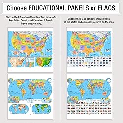
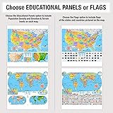
- Bring geography to life with the US & World Primary Classroom Map Pack by BrightWay Educational. Designed for grades 1-5, this vibrant set features detailed maps of both the United States and the World, with easy-to-read fonts and bright colors for clear differentiation of countries, territories, and physical features. These maps were developed alongside teachers to ensure the maps enhance classroom learning and spark curiosity in young minds. These maps are constantly being updated, making the maps the most up-to-date on the market. Map Details: World Map (Eckert IV Projection): An equal-area projection that accurately portrays landmass sizes with minimal distortion. Features detailed insets of Europe, Antarctica, and the Arctic, as well as an inset showing all continents and oceans, providing an even broader view of global geography. United States Map (Albers Equal Area): Depicts the U.S. with accurate proportions for all landmasses, ensuring geographical accuracy. Pick Your Choice of Additional Map Features: Flags: Choose the flags variation to include flags of the countries pictured on the map for added educational value. Educational Panels: Choose the Educational Panels option to include the following panels: Population Density: Darker colors represent denser population areas, with major cities clearly highlighted. Elevation & Terrain: An elevation ramp showcases the range of high and low elevations, with major physical features depicted in shaded relief and a side-on elevation profile for additional context. Ideal for use in classrooms, homeschooling environments, and educational spaces, this US & World Primary Classroom Map Pack by BrightWay Educational is an essential tool for young learners to explore and understand the world around them.
$173,72
60% OFF
$69,49
IMPORT EASILY
By purchasing this product you can deduct VAT with your RUT number
$173,72
60% OFF
$69,49
Envío gratis
Con envío
Este producto viaja
de USA ![]() a tus manos en
a tus manos en
![]()
Conoce más detalles
Includes one map of the United States and one map of the World, each 36" x 30" and laminated. Bright, vivid colors clearly define countries and territories, making the maps visually engaging for students. Grades 1-5 Focused: Ideal for primary education classrooms, fostering foundational geography skills. Large, easy-to-read fonts help young learners quickly identify locations, enhancing readability and retention. Georeference and degree lines provide spatial context, helping students understand the global grid system. National capitals & global cities are prominently labeled, offering insight into political geography. Comprehensive physical features: Explore oceans, mountain ranges, lakes, rivers, and more, offering a full understanding of both political and physical geography.
Compra protegida
Disfruta de una experiencia de compra segura y confiable
![]() Garantía de entrega
Garantía de entrega
Con Tiendamia todas tus compras cuentan con Garantía de Entrega o devolución total de tu dinero.
Compras 100% seguras y garantizadas, para que pidas lo que sueñas y lo recibas del mundo a tu puerta.
Tarjetas de Débito y Crédito
Visa
Mastercard
American Express
Dinners
Discover
Alias
Pagos a través de PayPal
Compra procesada en dólares con dinero en cuenta o tarjetas internacionales.
PayPal

.svg)
