


Artículo: AMZ-0528028715
Rand McNally Easy to Read: Texas State Map
Format:
Map
Detalles del producto
Disponibilidad
En stock
En stock
Peso con empaque
0.20 kg
0.20 kg
Devolución
Sí
Sí
Condición
Nuevo
Nuevo
Producto de
Amazon
Amazon
Viaja desde
USA
USA
Sobre este producto
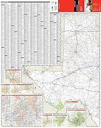
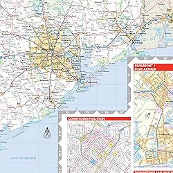
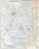
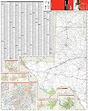
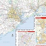
- Rand McNally's Easy To Read State Folded Map is a must-have for anyone traveling in and around Texas, offering unbeatable accuracy and reliability at a great price. Our trusted cartography shows all Interstate, U.S., state, and county highways, along with clearly indicated parks, points of interest, airports, county boundaries, and streets. The easy-to-use legend and detailed index make for quick and easy location of destinations. You'll see why Rand McNally folded maps have been the trusted standard for years. - Regularly updated, full-color maps. - 40% larger map with a bigger type size than the Rand McNally Folded Map. - Clearly labeled Interstate, U.S., state, and county highways. - Indications of parks, points of interest, airports, county boundaries, and more. - Mileage and driving times map. - Detailed index. - Convenient folded size. Coverage Area Detailed maps of: Abilene, Amarillo, Austin, Beaumont, Big Bend National Park, Bryan/College Station, Corpus Christi, Dallas/Fort Worth & Vicinity, El Paso, Galveston, Houston & Vicinity, Laredo, Lower Rio Grande Valley, Lubbock, Midland/Odessa, Port Arthur.
$43,76
60% OFF
$17,51
IMPORT EASILY
By purchasing this product you can deduct VAT with your RUT number
$43,76
60% OFF
$17,51
Envío gratis
Con envío
Este producto viaja
de USA ![]() a tus manos en
a tus manos en
![]()
Compra protegida
Disfruta de una experiencia de compra segura y confiable
![]() Garantía de entrega
Garantía de entrega
Con Tiendamia todas tus compras cuentan con Garantía de Entrega o devolución total de tu dinero.
Compras 100% seguras y garantizadas, para que pidas lo que sueñas y lo recibas del mundo a tu puerta.
Tarjetas de Débito y Crédito
Visa
Mastercard
American Express
Dinners
Discover
Alias
Pagos a través de PayPal
Compra procesada en dólares con dinero en cuenta o tarjetas internacionales.
PayPal

.svg)
